
iOS, Android and Windows App is a 3D Globe with Terrain Views
Add Catalogs, Add Local Offline Data, Add URL’s for Map Services Measure Linear and Map Swipe,Augmented Reality (Control View with your device’s sensors GPS/GNSS, Accelerometer, Gyroscope, Compass, other)
Support Mapping Services
Open Geospatial Consortium (OGC) Mapping Services – WMS, WMTS, WFS, WCS, WPS, XYZ/TMS Tiles
ESRI Dynamic REST Mapping Services (MapServer, FeatureServer,ImageServer as WMS)
Open Data Portal (Socrata, CKAN, CSW)
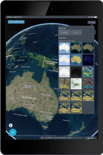
Raster Tile Basemap Picker
Uses BING Maps, Open Street Map, CartoDB Basemaps, Stamen Basemaps, ESRI Basemaps
Load Local Vector Data
Internet hosted file based data – CSV,GeoJSON, KML/KMZ,
ESRI Shapefile, CZML, GPX, GPKG Vector Features
JSON Catalog files
Ready for any Data
Easily view online Geospatial Data ESRI and OGC Mapping Services, File Based Formats, Draw and Edit Vector Data
GPS & IP Geolocation
Show your position, Show Coordinates Google Place Search and GeoCoding.
Jam Packed with Useful Features
Easy to use ! Easy to consume/view/discover data and perform visualization. Easily query data and get a feature info popup and lat long coordinates
Catalog Managing Data
Catalog Management Application that allows you to configure online mapping services for use in the app and also share those with friends and co-workers in a friendly JSON format.
Contact Us for Custom Versions and Offline Data
We are Selling White-Labeled Solutions
Earth Explorer 3D Map App is the Perfect App for Your Desktop and Tablet and Mobile Phone
App Feature
3D Terrain View/Scenes
Load data from Catalog
Split/Swipe Satellite imagery
3D Terrain View/Scenes
Load data from Catalog
Split/Swipe Satellite imagery
Earth Explorer 3D Map App
Supports 3D Tiles
These can be hosted online on a Static File Server or loaded onto the app for offline use make a zip file and rename it 3DTiles and load it into the app (iTunes filesharing )
3D Tiles can visualize 3D Buildings and Features, 3D Point Cloud Data (LiDAR), 3D Terrain surface, 3D Model of physical structures,etc.
You will soon be able to convert your 3D Data into 3D Tiles with our online conversion service http://geodataconverter.online
Earth Explorer
Videos with
Google Photorealistic
3D Buildings
Newsletter
Contact us for Custom Versions and Offline Data We are Selling White-Labeled Solutions
Schedule An Appointment Or Get an Instant Quote
✔ DisplayCoordinates
✔ Search Loaded Data
✔ Bing Search/Place/ Directions
✔ ExternalHWGNSS
✔ anyScreenSizeOrientation
✔ Charting
✔ Smart Url’s
✔ Bing Maps -Imagery
✔ Placemark
100’s of Features
Fast and Powerful Mapping Engine
We designed Earth Explorer 3D Map app as a fun experiment initially being able to plan our outdoor adventures and travels. Visualize terrain data and quickly access mapping services to mashup local and internet data. Augmented Reality feature is fun and innovative.

Map Viewing
Configure different basemaps from our basemap picker or add a new one URL. Display Coordinates (GPS Lat Long, UTM, MGRS, USNG, Maidenhead) and Graticule Lines Our mapping engine is one of the fastest rendering of data.

Raster Tile Basemap Picker
Select Multiple Basemaps from open source and commercial providers. Google, Bing, ESRI, Stamen, Thunder forest, Open Street Map, HERE, Carto DB, NASA and others.

Attribute Grid with Search
View GeoPackage Vector Features Attributes and Search Future versions will offer support for CSV, GeoJSON, KML, GPX and Shapefile Tables

Measure Linear and Area
Measure Tools allow you to measure complex linear/lines and area/polygon measurements.

Augmented Reality
Control the camera view as if you were there and look around
Switch Map
Switch Map Between 3D Terrain, 2D or 3D Smooth

Vector Tiles
View PBF Vector Tiles is now fully supported in 1.1
Create and Edit GeoJSON
Create and Edit (digitize) GeoJSON
Change Screen Orientation
Ready to get started?
Download the app from your app store or contact us for custom builds and versions. For Windows, we have Windows MSI and EXE builds in addition to the Windows Store APPX
We Would Love to Hear From You
Please Feel Free to Suggest Features, Enhancements, ideas or Data to include
Tech Maven Geospatial is actively developing and supporting this app and has a large Roadmap of additional features and capabilities will be developed. We also encourage you to send us feedback.
Field Data Collection
Orange Maps Collector
If you are looking for an application that’s more centered around form-based field data collection surveys please check out our sister app Orange Maps Collector/GeoData Collector
Mobile GIS Viewer/Editor/Analysis
If your looking for GIS Editing/Data Creation and Analysis please check out our feature-rich 2D Mapping Apps Check out GeoData Explorer and Map Discovery
Supported Formats:
| Files | Services |
|---|---|
| GeoJSON & TopoJSON | OGC WMTS Raster TILES |
| KMZ/KML | OGC WMS |
| CZML | ESRI ArcGIS Map Services |
| GPX | ESRI ArcGIS Feature Services |
| TEXT -TSV, CSV | ESRI ArcGIS Image Services |
| ESRI Shapefile | Raster Tile Server (XYZ/TMS) |
| ESRI FileGDB via in App Conversion | OGC WFS - Web Feature Service |
| OGC GeoPackage vector features | Raster Tiles XYZ and TMS |
| SOS Sensors IOT | |
