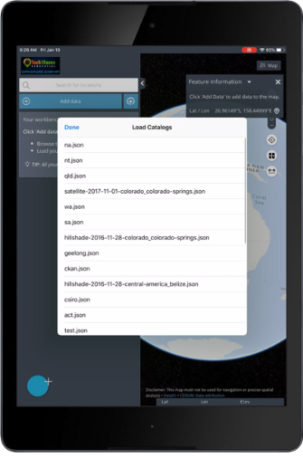
[et_pb_jt_material_blurb use_button=”off” use_icon=”on” font_icon=”%%160%%” icon_color=”#ffffff” use_circle=”on” circle_color=”#0c71c3″ use_icon_font_size=”on” icon_font_size=”45px” title=”Search Loaded Data” use_hover_elevation=”on” elevation_hover=”2″ hover_animation=”move_up” move_up_animation_distance=”4″ admin_label=”Search Loaded Data” _builder_version=”4.19.4″ background_color=”rgba(214,214,214,0.75)” title_font_size_tablet=”51″ title_line_height_tablet=”2″ body_font_size_tablet=”51″ body_line_height_tablet=”2″ z_index_tablet=”500″ title_text_shadow_horizontal_length_tablet=”0px” title_text_shadow_vertical_length_tablet=”0px” title_text_shadow_blur_strength_tablet=”1px” body_text_shadow_horizontal_length_tablet=”0px” body_text_shadow_vertical_length_tablet=”0px” body_text_shadow_blur_strength_tablet=”1px” button_text_shadow_horizontal_length_tablet=”0px” button_text_shadow_vertical_length_tablet=”0px” button_text_shadow_blur_strength_tablet=”1px” second_button_text_shadow_horizontal_length_tablet=”0px” second_button_text_shadow_vertical_length_tablet=”0px” second_button_text_shadow_blur_strength_tablet=”1px” box_shadow_horizontal_tablet=”0px” box_shadow_vertical_tablet=”0px” box_shadow_blur_tablet=”40px” box_shadow_spread_tablet=”0px” box_shadow_horizontal_button_tablet=”0px” box_shadow_vertical_button_tablet=”0px” box_shadow_blur_button_tablet=”40px” box_shadow_spread_button_tablet=”0px” box_shadow_horizontal_second_button_tablet=”0px” box_shadow_vertical_second_button_tablet=”0px” box_shadow_blur_second_button_tablet=”40px” box_shadow_spread_second_button_tablet=”0px” text_shadow_horizontal_length_tablet=”0px” text_shadow_vertical_length_tablet=”0px” text_shadow_blur_strength_tablet=”1px” global_colors_info=”{}” _i=”0″ _address=”6.0.0.0″ /][et_pb_jt_material_blurb use_button=”off” use_icon=”on” font_icon=”%%273%%” icon_color=”#ffffff” use_circle=”on” circle_color=”#0c71c3″ use_icon_font_size=”on” icon_font_size=”45px” title=”View Metadata” use_hover_elevation=”on” elevation_hover=”2″ hover_animation=”move_up” move_up_animation_distance=”4″ admin_label=”SmartURLs” _builder_version=”4.19.4″ background_color=”rgba(214,214,214,0.74)” title_font_size_tablet=”51″ title_line_height_tablet=”2″ body_font_size_tablet=”51″ body_line_height_tablet=”2″ z_index_tablet=”500″ title_text_shadow_horizontal_length_tablet=”0px” title_text_shadow_vertical_length_tablet=”0px” title_text_shadow_blur_strength_tablet=”1px” body_text_shadow_horizontal_length_tablet=”0px” body_text_shadow_vertical_length_tablet=”0px” body_text_shadow_blur_strength_tablet=”1px” button_text_shadow_horizontal_length_tablet=”0px” button_text_shadow_vertical_length_tablet=”0px” button_text_shadow_blur_strength_tablet=”1px” second_button_text_shadow_horizontal_length_tablet=”0px” second_button_text_shadow_vertical_length_tablet=”0px” second_button_text_shadow_blur_strength_tablet=”1px” box_shadow_horizontal_tablet=”0px” box_shadow_vertical_tablet=”0px” box_shadow_blur_tablet=”40px” box_shadow_spread_tablet=”0px” box_shadow_horizontal_button_tablet=”0px” box_shadow_vertical_button_tablet=”0px” box_shadow_blur_button_tablet=”40px” box_shadow_spread_button_tablet=”0px” box_shadow_horizontal_second_button_tablet=”0px” box_shadow_vertical_second_button_tablet=”0px” box_shadow_blur_second_button_tablet=”40px” box_shadow_spread_second_button_tablet=”0px” text_shadow_horizontal_length_tablet=”0px” text_shadow_vertical_length_tablet=”0px” text_shadow_blur_strength_tablet=”1px” global_colors_info=”{}” _i=”1″ _address=”6.0.0.1″ /][et_pb_jt_material_blurb use_button=”off” use_icon=”on” font_icon=”%%160%%” icon_color=”#ffffff” use_circle=”on” circle_color=”#0c71c3″ use_icon_font_size=”on” icon_font_size=”45px” title=”Charting” use_hover_elevation=”on” elevation_hover=”2″ hover_animation=”move_up” move_up_animation_distance=”4″ admin_label=”Charting” _builder_version=”4.19.4″ background_color=”rgba(214,214,214,0.75)” title_font_size_tablet=”51″ title_line_height_tablet=”2″ body_font_size_tablet=”51″ body_line_height_tablet=”2″ z_index_tablet=”500″ title_text_shadow_horizontal_length_tablet=”0px” title_text_shadow_vertical_length_tablet=”0px” title_text_shadow_blur_strength_tablet=”1px” body_text_shadow_horizontal_length_tablet=”0px” body_text_shadow_vertical_length_tablet=”0px” body_text_shadow_blur_strength_tablet=”1px” button_text_shadow_horizontal_length_tablet=”0px” button_text_shadow_vertical_length_tablet=”0px” button_text_shadow_blur_strength_tablet=”1px” second_button_text_shadow_horizontal_length_tablet=”0px” second_button_text_shadow_vertical_length_tablet=”0px” second_button_text_shadow_blur_strength_tablet=”1px” box_shadow_horizontal_tablet=”0px” box_shadow_vertical_tablet=”0px” box_shadow_blur_tablet=”40px” box_shadow_spread_tablet=”0px” box_shadow_horizontal_button_tablet=”0px” box_shadow_vertical_button_tablet=”0px” box_shadow_blur_button_tablet=”40px” box_shadow_spread_button_tablet=”0px” box_shadow_horizontal_second_button_tablet=”0px” box_shadow_vertical_second_button_tablet=”0px” box_shadow_blur_second_button_tablet=”40px” box_shadow_spread_second_button_tablet=”0px” text_shadow_horizontal_length_tablet=”0px” text_shadow_vertical_length_tablet=”0px” text_shadow_blur_strength_tablet=”1px” locked=”off” global_colors_info=”{}” _i=”2″ _address=”6.0.0.2″ /][et_pb_jt_material_blurb use_button=”off” use_icon=”on” font_icon=”||divi||400″ icon_color=”#ffffff” use_circle=”on” circle_color=”#0c71c3″ use_icon_font_size=”on” icon_font_size=”45px” title=”Charting” use_hover_elevation=”on” elevation_hover=”2″ hover_animation=”move_up” move_up_animation_distance=”4″ admin_label=”Bing Maps -Imagery” _builder_version=”4.19.4″ background_color=”rgba(214,214,214,0.74)” title_font_size_tablet=”51″ title_line_height_tablet=”2″ body_font_size_tablet=”51″ body_line_height_tablet=”2″ z_index_tablet=”500″ title_text_shadow_horizontal_length_tablet=”0px” title_text_shadow_vertical_length_tablet=”0px” title_text_shadow_blur_strength_tablet=”1px” body_text_shadow_horizontal_length_tablet=”0px” body_text_shadow_vertical_length_tablet=”0px” body_text_shadow_blur_strength_tablet=”1px” button_text_shadow_horizontal_length_tablet=”0px” button_text_shadow_vertical_length_tablet=”0px” button_text_shadow_blur_strength_tablet=”1px” second_button_text_shadow_horizontal_length_tablet=”0px” second_button_text_shadow_vertical_length_tablet=”0px” second_button_text_shadow_blur_strength_tablet=”1px” box_shadow_horizontal_tablet=”0px” box_shadow_vertical_tablet=”0px” box_shadow_blur_tablet=”40px” box_shadow_spread_tablet=”0px” box_shadow_horizontal_button_tablet=”0px” box_shadow_vertical_button_tablet=”0px” box_shadow_blur_button_tablet=”40px” box_shadow_spread_button_tablet=”0px” box_shadow_horizontal_second_button_tablet=”0px” box_shadow_vertical_second_button_tablet=”0px” box_shadow_blur_second_button_tablet=”40px” box_shadow_spread_second_button_tablet=”0px” text_shadow_horizontal_length_tablet=”0px” text_shadow_vertical_length_tablet=”0px” text_shadow_blur_strength_tablet=”1px” locked=”off” global_colors_info=”{}” _i=”3″ _address=”6.0.0.3″ /][et_pb_jt_material_blurb use_button=”off” use_icon=”on” font_icon=”%%252%%” icon_color=”#ffffff” use_circle=”on” circle_color=”#0c71c3″ use_icon_font_size=”on” icon_font_size=”45px” title=”Export/Print PNG/PDF of Map” use_hover_elevation=”on” elevation_hover=”2″ hover_animation=”move_up” move_up_animation_distance=”4″ disabled_on=”on|on|on” admin_label=”SmartURLs” _builder_version=”4.19.4″ background_color=”rgba(214,214,214,0.73)” title_font_size_tablet=”51″ title_line_height_tablet=”2″ body_font_size_tablet=”51″ body_line_height_tablet=”2″ z_index_tablet=”500″ title_text_shadow_horizontal_length_tablet=”0px” title_text_shadow_vertical_length_tablet=”0px” title_text_shadow_blur_strength_tablet=”1px” body_text_shadow_horizontal_length_tablet=”0px” body_text_shadow_vertical_length_tablet=”0px” body_text_shadow_blur_strength_tablet=”1px” button_text_shadow_horizontal_length_tablet=”0px” button_text_shadow_vertical_length_tablet=”0px” button_text_shadow_blur_strength_tablet=”1px” second_button_text_shadow_horizontal_length_tablet=”0px” second_button_text_shadow_vertical_length_tablet=”0px” second_button_text_shadow_blur_strength_tablet=”1px” box_shadow_horizontal_tablet=”0px” box_shadow_vertical_tablet=”0px” box_shadow_blur_tablet=”40px” box_shadow_spread_tablet=”0px” box_shadow_horizontal_button_tablet=”0px” box_shadow_vertical_button_tablet=”0px” box_shadow_blur_button_tablet=”40px” box_shadow_spread_button_tablet=”0px” box_shadow_horizontal_second_button_tablet=”0px” box_shadow_vertical_second_button_tablet=”0px” box_shadow_blur_second_button_tablet=”40px” box_shadow_spread_second_button_tablet=”0px” text_shadow_horizontal_length_tablet=”0px” text_shadow_vertical_length_tablet=”0px” text_shadow_blur_strength_tablet=”1px” disabled=”on” global_colors_info=”{}” _i=”4″ _address=”6.0.0.4″ /][et_pb_jt_material_blurb use_button=”off” use_icon=”on” font_icon=”%%304%%” icon_color=”#ffffff” use_circle=”on” circle_color=”#0c71c3″ use_icon_font_size=”on” icon_font_size=”45px” title=”Share Link and Embed code” use_hover_elevation=”on” elevation_hover=”2″ hover_animation=”move_up” move_up_animation_distance=”4″ disabled_on=”on|on|on” admin_label=”SmartURLs” _builder_version=”4.16″ background_color=”rgba(214,214,214,0.44)” title_font_size_tablet=”51″ title_line_height_tablet=”2″ body_font_size_tablet=”51″ body_line_height_tablet=”2″ z_index_tablet=”500″ title_text_shadow_horizontal_length_tablet=”0px” title_text_shadow_vertical_length_tablet=”0px” title_text_shadow_blur_strength_tablet=”1px” body_text_shadow_horizontal_length_tablet=”0px” body_text_shadow_vertical_length_tablet=”0px” body_text_shadow_blur_strength_tablet=”1px” button_text_shadow_horizontal_length_tablet=”0px” button_text_shadow_vertical_length_tablet=”0px” button_text_shadow_blur_strength_tablet=”1px” second_button_text_shadow_horizontal_length_tablet=”0px” second_button_text_shadow_vertical_length_tablet=”0px” second_button_text_shadow_blur_strength_tablet=”1px” box_shadow_horizontal_tablet=”0px” box_shadow_vertical_tablet=”0px” box_shadow_blur_tablet=”40px” box_shadow_spread_tablet=”0px” box_shadow_horizontal_button_tablet=”0px” box_shadow_vertical_button_tablet=”0px” box_shadow_blur_button_tablet=”40px” box_shadow_spread_button_tablet=”0px” box_shadow_horizontal_second_button_tablet=”0px” box_shadow_vertical_second_button_tablet=”0px” box_shadow_blur_second_button_tablet=”40px” box_shadow_spread_second_button_tablet=”0px” text_shadow_horizontal_length_tablet=”0px” text_shadow_vertical_length_tablet=”0px” text_shadow_blur_strength_tablet=”1px” disabled=”on” global_colors_info=”{}” _i=”5″ _address=”6.0.0.5″ /]
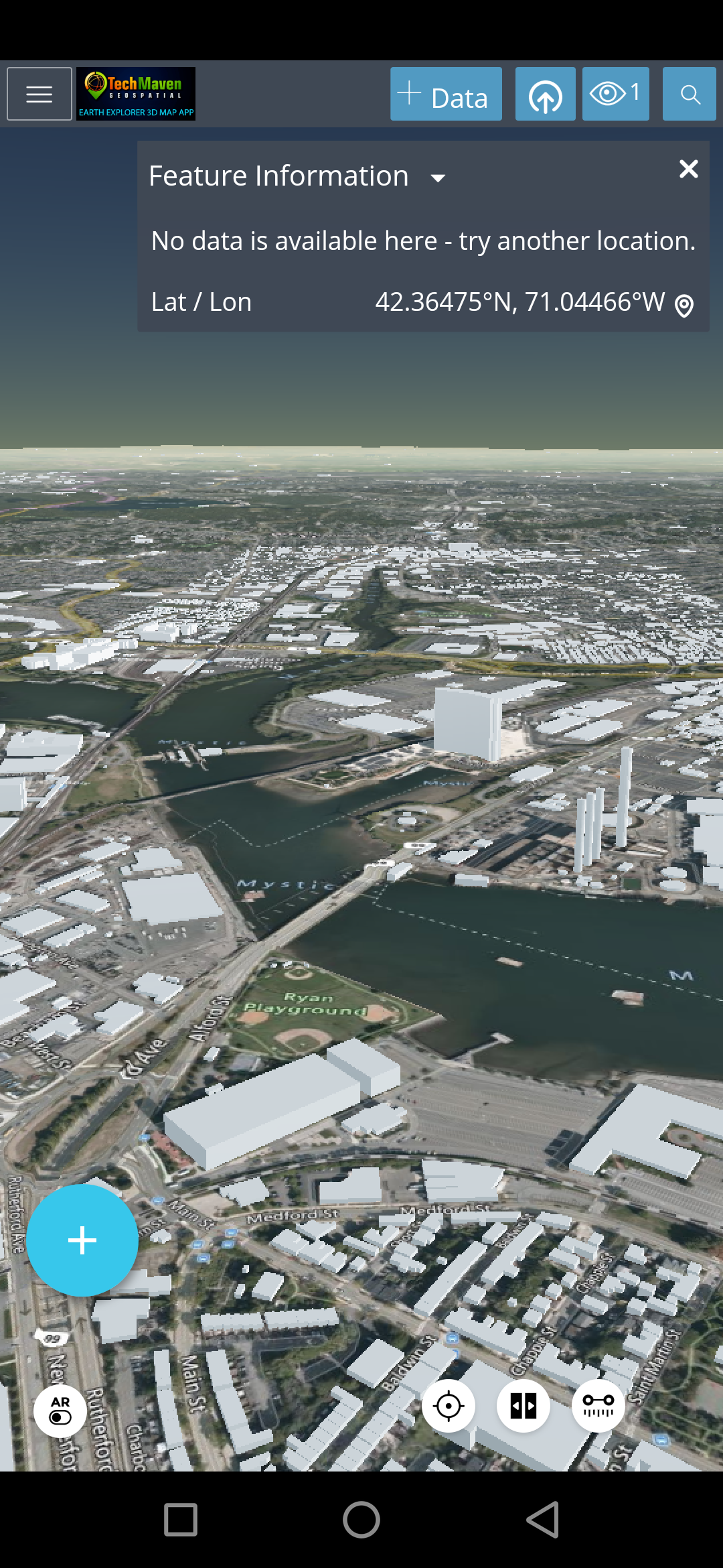
[et_pb_jt_material_blurb use_button=”off” use_icon=”on” font_icon=”%%372%%” icon_color=”#ffffff” use_circle=”on” circle_color=”#0c71c3″ use_icon_font_size=”on” icon_font_size=”45px” title=”Bing” use_hover_elevation=”on” elevation_hover=”2″ hover_animation=”move_up” move_up_animation_distance=”4″ admin_label=”Bing Search/Place/Directions” _builder_version=”4.19.4″ background_color=”rgba(214,214,214,0.74)” title_font_size_tablet=”51″ title_line_height_tablet=”2″ body_font_size_tablet=”51″ body_line_height_tablet=”2″ z_index_tablet=”500″ title_text_shadow_horizontal_length_tablet=”0px” title_text_shadow_vertical_length_tablet=”0px” title_text_shadow_blur_strength_tablet=”1px” body_text_shadow_horizontal_length_tablet=”0px” body_text_shadow_vertical_length_tablet=”0px” body_text_shadow_blur_strength_tablet=”1px” button_text_shadow_horizontal_length_tablet=”0px” button_text_shadow_vertical_length_tablet=”0px” button_text_shadow_blur_strength_tablet=”1px” second_button_text_shadow_horizontal_length_tablet=”0px” second_button_text_shadow_vertical_length_tablet=”0px” second_button_text_shadow_blur_strength_tablet=”1px” box_shadow_horizontal_tablet=”0px” box_shadow_vertical_tablet=”0px” box_shadow_blur_tablet=”40px” box_shadow_spread_tablet=”0px” box_shadow_horizontal_button_tablet=”0px” box_shadow_vertical_button_tablet=”0px” box_shadow_blur_button_tablet=”40px” box_shadow_spread_button_tablet=”0px” box_shadow_horizontal_second_button_tablet=”0px” box_shadow_vertical_second_button_tablet=”0px” box_shadow_blur_second_button_tablet=”40px” box_shadow_spread_second_button_tablet=”0px” text_shadow_horizontal_length_tablet=”0px” text_shadow_vertical_length_tablet=”0px” text_shadow_blur_strength_tablet=”1px” global_colors_info=”{}” _i=”0″ _address=”6.0.1.0″ /][et_pb_jt_material_blurb url=”https://earthexplorer.techmaven.net/Feature/swipe-compare/” use_button=”off” use_icon=”on” font_icon=”%%322%%” icon_color=”#ffffff” use_circle=”on” circle_color=”#0c71c3″ use_icon_font_size=”on” icon_font_size=”45px” title=”Displays Coordinates” use_hover_elevation=”on” elevation_hover=”2″ hover_animation=”move_up” move_up_animation_distance=”4″ admin_label=”DisplayCoordinates” _builder_version=”4.19.4″ background_color=”rgba(214,214,214,0.75)” title_font_size_tablet=”51″ title_line_height_tablet=”2″ body_font_size_tablet=”51″ body_line_height_tablet=”2″ z_index_tablet=”500″ title_text_shadow_horizontal_length_tablet=”0px” title_text_shadow_vertical_length_tablet=”0px” title_text_shadow_blur_strength_tablet=”1px” body_text_shadow_horizontal_length_tablet=”0px” body_text_shadow_vertical_length_tablet=”0px” body_text_shadow_blur_strength_tablet=”1px” button_text_shadow_horizontal_length_tablet=”0px” button_text_shadow_vertical_length_tablet=”0px” button_text_shadow_blur_strength_tablet=”1px” second_button_text_shadow_horizontal_length_tablet=”0px” second_button_text_shadow_vertical_length_tablet=”0px” second_button_text_shadow_blur_strength_tablet=”1px” box_shadow_horizontal_tablet=”0px” box_shadow_vertical_tablet=”0px” box_shadow_blur_tablet=”40px” box_shadow_spread_tablet=”0px” box_shadow_horizontal_button_tablet=”0px” box_shadow_vertical_button_tablet=”0px” box_shadow_blur_button_tablet=”40px” box_shadow_spread_button_tablet=”0px” box_shadow_horizontal_second_button_tablet=”0px” box_shadow_vertical_second_button_tablet=”0px” box_shadow_blur_second_button_tablet=”40px” box_shadow_spread_second_button_tablet=”0px” text_shadow_horizontal_length_tablet=”0px” text_shadow_vertical_length_tablet=”0px” text_shadow_blur_strength_tablet=”1px” global_colors_info=”{}” _i=”1″ _address=”6.0.1.1″ /][et_pb_jt_material_blurb url=”https://earthexplorer.techmaven.net/Feature/geolocation-and-gnss-settings/” use_button=”off” use_icon=”on” font_icon=”%%166%%” icon_color=”#ffffff” use_circle=”on” circle_color=”#0c71c3″ use_icon_font_size=”on” icon_font_size=”45px” title=”Support for high precision external Bluetooth GPS / GNSS Receivers” use_hover_elevation=”on” elevation_hover=”2″ hover_animation=”move_up” move_up_animation_distance=”4″ admin_label=”ExternalHWGNSS” _builder_version=”4.19.4″ background_color=”rgba(214,214,214,0.75)” title_font_size_tablet=”51″ title_line_height_tablet=”2″ body_font_size_tablet=”51″ body_line_height_tablet=”2″ z_index_tablet=”500″ title_text_shadow_horizontal_length_tablet=”0px” title_text_shadow_vertical_length_tablet=”0px” title_text_shadow_blur_strength_tablet=”1px” body_text_shadow_horizontal_length_tablet=”0px” body_text_shadow_vertical_length_tablet=”0px” body_text_shadow_blur_strength_tablet=”1px” button_text_shadow_horizontal_length_tablet=”0px” button_text_shadow_vertical_length_tablet=”0px” button_text_shadow_blur_strength_tablet=”1px” second_button_text_shadow_horizontal_length_tablet=”0px” second_button_text_shadow_vertical_length_tablet=”0px” second_button_text_shadow_blur_strength_tablet=”1px” box_shadow_horizontal_tablet=”0px” box_shadow_vertical_tablet=”0px” box_shadow_blur_tablet=”40px” box_shadow_spread_tablet=”0px” box_shadow_horizontal_button_tablet=”0px” box_shadow_vertical_button_tablet=”0px” box_shadow_blur_button_tablet=”40px” box_shadow_spread_button_tablet=”0px” box_shadow_horizontal_second_button_tablet=”0px” box_shadow_vertical_second_button_tablet=”0px” box_shadow_blur_second_button_tablet=”40px” box_shadow_spread_second_button_tablet=”0px” text_shadow_horizontal_length_tablet=”0px” text_shadow_vertical_length_tablet=”0px” text_shadow_blur_strength_tablet=”1px” global_colors_info=”{}” _i=”2″ _address=”6.0.1.2″ /]
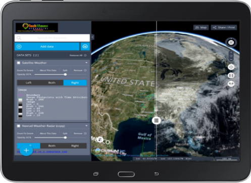
[et_pb_jt_material_blurb url=”https://earthexplorer.techmaven.net/Feature/screen-size-and-orientation/%20” use_button=”off” use_icon=”on” font_icon=”%%15%%” icon_color=”#ffffff” use_circle=”on” circle_color=”#0c71c3″ use_icon_font_size=”on” icon_font_size=”45px” title=”Works Landscape or Portrait Mode” use_hover_elevation=”on” elevation_hover=”2″ hover_animation=”move_up” move_up_animation_distance=”4″ admin_label=”anyScreenSizeOrientation” _builder_version=”4.19.4″ background_color=”rgba(214,214,214,0.74)” title_font_size_tablet=”51″ title_line_height_tablet=”2″ body_font_size_tablet=”51″ body_line_height_tablet=”2″ z_index_tablet=”500″ title_text_shadow_horizontal_length_tablet=”0px” title_text_shadow_vertical_length_tablet=”0px” title_text_shadow_blur_strength_tablet=”1px” body_text_shadow_horizontal_length_tablet=”0px” body_text_shadow_vertical_length_tablet=”0px” body_text_shadow_blur_strength_tablet=”1px” button_text_shadow_horizontal_length_tablet=”0px” button_text_shadow_vertical_length_tablet=”0px” button_text_shadow_blur_strength_tablet=”1px” second_button_text_shadow_horizontal_length_tablet=”0px” second_button_text_shadow_vertical_length_tablet=”0px” second_button_text_shadow_blur_strength_tablet=”1px” box_shadow_horizontal_tablet=”0px” box_shadow_vertical_tablet=”0px” box_shadow_blur_tablet=”40px” box_shadow_spread_tablet=”0px” box_shadow_horizontal_button_tablet=”0px” box_shadow_vertical_button_tablet=”0px” box_shadow_blur_button_tablet=”40px” box_shadow_spread_button_tablet=”0px” box_shadow_horizontal_second_button_tablet=”0px” box_shadow_vertical_second_button_tablet=”0px” box_shadow_blur_second_button_tablet=”40px” box_shadow_spread_second_button_tablet=”0px” text_shadow_horizontal_length_tablet=”0px” text_shadow_vertical_length_tablet=”0px” text_shadow_blur_strength_tablet=”1px” global_colors_info=”{}” _i=”0″ _address=”6.0.2.0″ /][et_pb_jt_material_blurb url=”https://earthexplorer.techmaven.net/Feature/screen-size-and-orientation/%20” use_button=”off” use_icon=”on” font_icon=”%%69%%” icon_color=”#ffffff” use_circle=”on” circle_color=”#0c71c3″ use_icon_font_size=”on” icon_font_size=”45px” title=”Re-order data layers” use_hover_elevation=”on” elevation_hover=”2″ hover_animation=”move_up” move_up_animation_distance=”4″ admin_label=”anyScreenSizeOrientation” _builder_version=”4.19.4″ background_color=”rgba(214,214,214,0.74)” title_font_size_tablet=”51″ title_line_height_tablet=”2″ body_font_size_tablet=”51″ body_line_height_tablet=”2″ z_index_tablet=”500″ title_text_shadow_horizontal_length_tablet=”0px” title_text_shadow_vertical_length_tablet=”0px” title_text_shadow_blur_strength_tablet=”1px” body_text_shadow_horizontal_length_tablet=”0px” body_text_shadow_vertical_length_tablet=”0px” body_text_shadow_blur_strength_tablet=”1px” button_text_shadow_horizontal_length_tablet=”0px” button_text_shadow_vertical_length_tablet=”0px” button_text_shadow_blur_strength_tablet=”1px” second_button_text_shadow_horizontal_length_tablet=”0px” second_button_text_shadow_vertical_length_tablet=”0px” second_button_text_shadow_blur_strength_tablet=”1px” box_shadow_horizontal_tablet=”0px” box_shadow_vertical_tablet=”0px” box_shadow_blur_tablet=”40px” box_shadow_spread_tablet=”0px” box_shadow_horizontal_button_tablet=”0px” box_shadow_vertical_button_tablet=”0px” box_shadow_blur_button_tablet=”40px” box_shadow_spread_button_tablet=”0px” box_shadow_horizontal_second_button_tablet=”0px” box_shadow_vertical_second_button_tablet=”0px” box_shadow_blur_second_button_tablet=”40px” box_shadow_spread_second_button_tablet=”0px” text_shadow_horizontal_length_tablet=”0px” text_shadow_vertical_length_tablet=”0px” text_shadow_blur_strength_tablet=”1px” global_colors_info=”{}” _i=”1″ _address=”6.0.2.1″ /][et_pb_jt_material_blurb use_button=”off” use_icon=”on” font_icon=”%%373%%” icon_color=”#ffffff” use_circle=”on” circle_color=”#0c71c3″ use_icon_font_size=”on” icon_font_size=”45px” title=”Timeslider” use_hover_elevation=”on” elevation_hover=”2″ hover_animation=”move_up” move_up_animation_distance=”4″ admin_label=”anyScreenSizeOrientation” _builder_version=”4.19.4″ background_color=”rgba(214,214,214,0.75)” title_font_size_tablet=”51″ title_line_height_tablet=”2″ body_font_size_tablet=”51″ body_line_height_tablet=”2″ z_index_tablet=”500″ title_text_shadow_horizontal_length_tablet=”0px” title_text_shadow_vertical_length_tablet=”0px” title_text_shadow_blur_strength_tablet=”1px” body_text_shadow_horizontal_length_tablet=”0px” body_text_shadow_vertical_length_tablet=”0px” body_text_shadow_blur_strength_tablet=”1px” button_text_shadow_horizontal_length_tablet=”0px” button_text_shadow_vertical_length_tablet=”0px” button_text_shadow_blur_strength_tablet=”1px” second_button_text_shadow_horizontal_length_tablet=”0px” second_button_text_shadow_vertical_length_tablet=”0px” second_button_text_shadow_blur_strength_tablet=”1px” box_shadow_horizontal_tablet=”0px” box_shadow_vertical_tablet=”0px” box_shadow_blur_tablet=”40px” box_shadow_spread_tablet=”0px” box_shadow_horizontal_button_tablet=”0px” box_shadow_vertical_button_tablet=”0px” box_shadow_blur_button_tablet=”40px” box_shadow_spread_button_tablet=”0px” box_shadow_horizontal_second_button_tablet=”0px” box_shadow_vertical_second_button_tablet=”0px” box_shadow_blur_second_button_tablet=”40px” box_shadow_spread_second_button_tablet=”0px” text_shadow_horizontal_length_tablet=”0px” text_shadow_vertical_length_tablet=”0px” text_shadow_blur_strength_tablet=”1px” global_colors_info=”{}” _i=”2″ _address=”6.0.2.2″ /]